How China’s military plugs into the global space sector
Posted By Samuel Strickland on October 26, 2022 @ 14:30

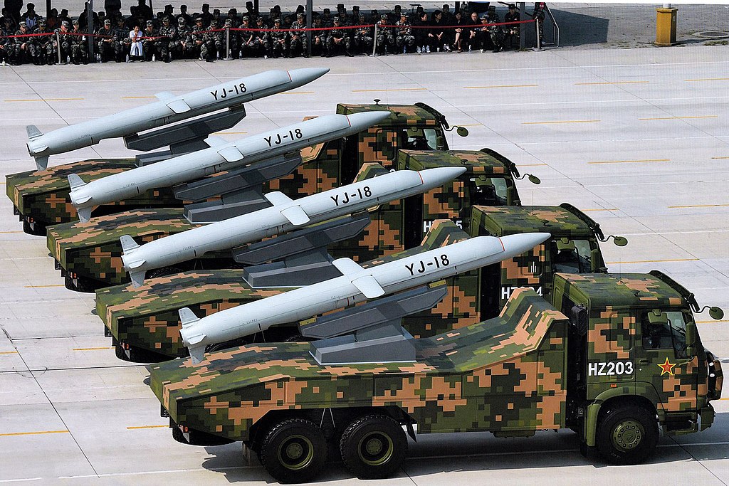
In August, a photograph [1] of China’s Dalian shipyard surfaced on Chinese social media site Weibo showing five hulls of Luyang III–type vessels under construction. Once completed, these destroyers will sail out into blue waters, projecting the might of the Chinese navy and carrying with them a lethal high-tech projectile—the YJ-18A missile [2]. Able to severely damage [3] a warship with tens of thousands of tons of displacement in a single strike, the YJ-18A can sprint up to Mach 3.0 before impact and carry a 300-kilogram warhead. The result is a serious threat to US carrier strike groups in the South China Sea and beyond.
While the YJ-18A is designed to skim just five to 10 meters above sea level, it is also an example of China’s growing sophistication in outer space. The missile, designed to be almost impossible to intercept, relies on a constellation of Chinese satellites known as BeiDou.
While the civilian benefits [4] are numerous, BeiDou is primarily a military technology. Similar to the United States’ GPS, China’s BeiDou is used to provide position, navigation and timing services to users. The catalyst for the development of this satellite system was likely the 1996 Taiwan Strait crisis [5]. During a campaign of electoral intimidation aimed at Taiwan, the People’s Liberation Army fired missiles into the strait. However, the campaign backfired when a disruption to its GPS access caused China to lose track of its own missiles. BeiDou was announced shortly afterwards.
The BeiDou system was completed [6] In June 2020. The final launch was a colossal national achievement, representing the culmination of two decades of work at a cost of more than US$9 billion. President Xi Jinping celebrated [7] the finished system as a shining example of China’s ‘great rejuvenation’ as a superpower.
Yet, BeiDou is also a shining example of China’s military–civil fusion strategy [8].
Xi has favoured military–civil fusion as a method to harness entrepreneurs, researchers and scholars to spur the development of the PLA. The strategy aims to create an ecosystem in which even overtly civilian companies and universities collaborate with the military.
In the case of BeiDou, China has leveraged many of its academic researchers and their partners to propel its creation and refinement. One prominent example of this is Wuhan University.
The university is supervised [9] by the State Administration of Science, Technology and Industry for National Defence, which in turn is overseen by the State Council’s Central Commission for Integrated Military and Civilian Development. Along with its strong links to the military sector, there have also been allegations [10] that the university conducts cyberattacks on behalf of the military. As a result, it has been categorised as a very high-risk institution [11] for collaboration.
With the lines between the civilian and the military blurred by the State Council, Wuhan University can use its international affiliations to support the PLA. Once such affiliation is with the International GNSS Service [12], a voluntary federation comprising 350 organizations across 118 countries. Its mission is to provide open-access data products on navigational satellites for the benefit of its members and the wider scientific community.
Historically, China has faced difficulties establishing its own satellite tracking stations. Its ground station in Kiribati became a thorny issue [13] during the Pacific island nation’s 2003 election. More recently, Chinese stations in Argentina, Brazil, Bolivia, Chile and Venezuela have provoked concerns [14]. While China still needs these large stations for its wider ambitions in outer space, it can readily access an existing global network of 520 smaller reference stations that monitor navigational satellites.
Wuhan University has used the International GNSS Service to access an invaluable stream of data. Its centre on satellite systems hosts one of the service’s global data centres [15]. Through this, Wuhan University can utilise a worldwide network that stretches from Canberra to Reykjavik, allowing the Chinese military to plug into the global space sector.
This data is then available to support projects funded by the PLA. The Wuhan centre has reported involvement in at least 30 research and 300 engineering initiatives. Such work receives funding from the military sector to shore up deficiencies and gain strategic edges. One example of a project [16] that used international data looked at strategies to decrease ionospheric interference for BeiDou. Such a study—or those like it—almost certainly culminates to support capabilities like the YJ-18A missile.
As a result of such efforts, the Wuhan centre on satellite systems received an award [17] for ‘Outstanding Contribution’ by the PLA’s General Armaments Department (since renamed the Equipment Development Department).
Organisations like the International GNSS Service need to be aware that even overtly civilian entities like Wuhan University can be intertwined with the Chinese military. Collaboration with high-risk institutions must be done with extreme care to ensure data and products intended to support international science and commerce are not redirected towards unwanted military uses.
Article printed from The Strategist: https://www.aspistrategist.org.au
URL to article: https://www.aspistrategist.org.au/how-chinas-military-plugs-into-the-global-space-sector/
URLs in this post:
[1] photograph: https://www.navalnews.com/naval-news/2022/08/five-type-052d-destroyers-under-construction-in-china/
[2] YJ-18A missile: https://missilethreat.csis.org/missile/yj-18/
[3] severely damage: https://navalpost.com/chinese-becomes-more-dangerous-with-yj-18-missile/
[4] civilian benefits: https://www.reuters.com/world/china/chinas-beidou-navigation-system-serve-156-bln-home-market-by-2025-2021-05-26/
[5] 1996 Taiwan Strait crisis: https://www.scmp.com/article/698161/unforgettable-humiliation-led-development-gps-equivalent
[6] BeiDou system was completed: https://www.space.com/china-launches-final-beidou-navigation-satellite.html
[7] President Xi Jinping celebrated: http://en.beidou.gov.cn/WHATSNEWS/202008/t20200803_21013.html
[8] military–civil fusion strategy: https://foreignpolicy.com/2021/02/05/dont-underestimate-chinas-military-civil-fusion-efforts/
[9] supervised: https://static1.squarespace.com/static/566ef8b4d8af107232d5358a/t/5d95fb48a0bfc672d825e346/1570110297719/Open+Arms.pdf#page=6
[10] allegations: https://www.moneycontrol.com/news/opinion/chinas-covert-operations-closer-scrutiny-on-university-grants-and-language-institutions-is-welcome-6360101.html
[11] very high-risk institution: https://unitracker.aspi.org.au/universities/wuhan-university/
[12] International GNSS Service: https://igs.org/
[13] thorny issue: https://www.cis.org.au/commentary/opinion/why-china-first-wooed-then-jilted-kiribati/
[14] concerns: https://features.csis.org/hiddenreach/china-ground-stations-space/
[15] global data centres: http://www.igs.gnsswhu.cn/index.php/home/index.html?lang=zh-cn
[16] project: https://www.mdpi.com/2072-4292/11/21/2551/pdf
[17] award: http://www.igs.gnsswhu.cn/index.php/home/index/about.html
Click here to print.