China’s research in several advanced sensor technologies vital to military navigation and targeting is overwhelmingly ahead of the three AUKUS partners, the United States, United Kingdom and Australia.
Even if the three team up with likeminded Indo-Pacific countries Japan and South Korea, they do not match the Chinese output in high-impact research.
This is a key finding of ASPI’s latest update to its ground-breaking Critical Technology Tracker which compares levels of high-impact technological research worldwide. The update, released today, focuses on two key technology clusters in which breakthroughs will have major implications for future industrial, societal and military capabilities—advanced sensors and biotechnologies.
The tracker has now measured the amount of high-impact research by country across 64 technologies. China maintains its overall dominance, leading in 53 technologies against 11 for the US. This article focuses on advanced sensors. A second Strategist piece will tackle biotechnology.
High impact research is a key performance measure of scientific and technological capability. For example, the recent boom in Artificial Intelligence (AI) applications such as ChatGPT have grabbed global attention seemingly out of nowhere but are in fact based on decades of quiet research and advances across AI and computing.
Although North America has the largest share of the $200 billion remote sensor market with 41%, the tracker indicates China’s strong future trajectory through its huge share of papers in the top 10% of highly cited publications, especially in inertial navigation systems (44%), photonic sensors (43.7%), multispectral and hyperspectral imaging sensors (48.9%) and sonar sensors (49.4%).
The advanced sensor technologies included in the tracker are used for sensing, timing and navigation. They are comprised of devices with extremely sensitive detection capabilities for magnetic and gravitational fields, light and radio waves, and measuring time with atomic precision. The seven technologies are atomic clocks, inertial navigation systems, gravitational force sensors, magnetic field sensors, multispectral and hyperspectral imaging sensors, satellite positioning and navigation, and radar.
Three sensor technologies covered in previous releases are—sonar and acoustic sensors, photonic sensors and quantum sensors.
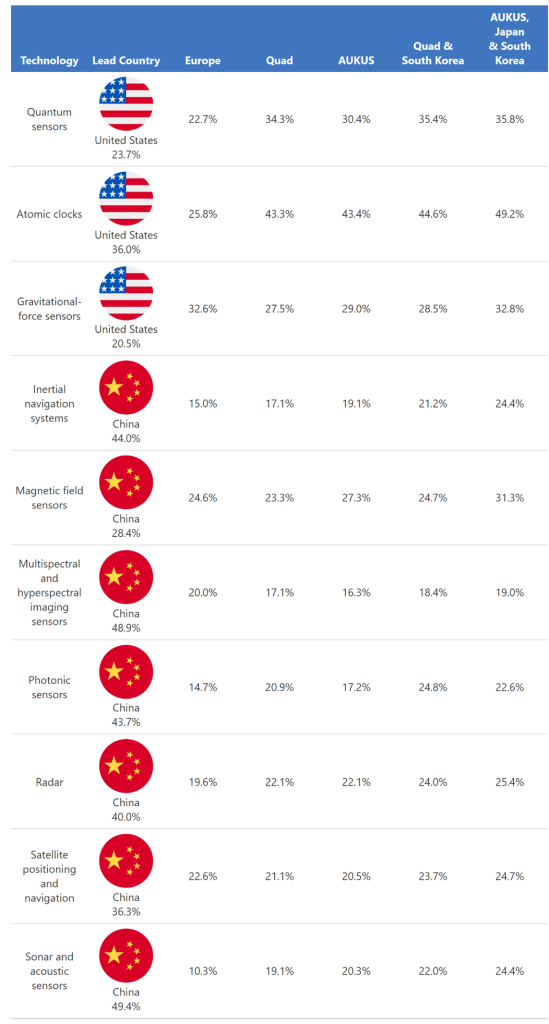
Our table shows our analysis of advanced sensor technologies and identifies the lead country with the highest percentage of papers in the top 10% of highly cited papers. The Critical Technology Tracker shows that China leads in seven of the 10 advanced sensor technologies—reflecting the massive effort and investment Beijing has made in these areas in recent years.
Four of these technologies have a high technology monopoly risk and can translate to future technological dominance. However, the stark nature of the challenge becomes clearer when we add the outputs of the AUKUS countries and other plausible partners.
Even if the three AUKUS partners join efforts, they still lag badly in six out of the seven technologies in which China leads, and they are barely neck-and-neck in the seventh, magnetic field sensors.
And if AUKUS were to expand and work with Japan and South Korea, they still wouldn’t catch up in those six fields. When Europe is added, the multinational grouping would creep ahead in radar and satellite positioning and navigation, but would still trail behind China in the other fields.
In a recent summit with the leaders of Japan and South Korea, US President Joe Biden reaffirmed US intentions to increase military and economic ties in a trilateral partnership. Japan, meanwhile, has expressed an interest in joining the non-submarine aspects of AUKUS technology collaboration—a gesture well received in the AUKUS capitals.
Each of these technologies is vital to our economies, our militaries, and our everyday lives. Global positioning systems (GPS), for example, are used by billions of people every day and are indispensable for defence forces for everything from situational awareness to guiding munitions. But their accuracy depends on precise timing using signals from atomic clocks on the ground and several GPS satellites in orbit.
Inertial navigation systems—which have long been an essential part of missile guidance—use a range of sensors to calculate the position of an object relative to its starting reference point without the need for continuous GPS references. This can become important if GPS networks are hit by jamming and spoofing attacks.
Likewise, ground-penetrating radar sensors—equally less reliant on GPS—can scan and map the ground with radio waves, which is useful for forensics, archeology and landmine detection.
Magnetic and gravitational field sensors have important applications in and beyond navigation. They can peer through dirt, rock and water to reveal information about the lay of the land. When coupled with a drone, these sensors provide valuable insights in land surveys and mineral exploration.
Gravitational field sensors can be used to monitor seismic and volcanic activity and detect hollow cavities and hydrocarbon reserves.
Quantum sensors can also be made to measure magnetic and gravitational fields but with higher sensitivity, better spatial resolution and a faster response rate.
Photonic sensors have applications in medicine (measuring blood saturation or glucose levels), environmental monitoring (measuring pressure and temperature), biochemical sensing (toxic chemicals) and autonomous systems (with laser imaging and detection).
Commercial satellite imaging is already highly capable, with a spatial resolution of a 25cm × 25cm pixel on earth, the size of a laptop. However, multispectral and hyperspectral imaging provides additional information by capturing specific colours, enabling the detection of chemical elements, for example, which is useful for agriculture, mineral prospecting and many other fields. It could, for instance, detect the spectral signature of chlorophyll—a key compound in green plants—across an area of land to counter ‘greenwashing’ by countries trying to inflate their carbon reduction measures. For example, earth images from Hisui, Japan’s hyperspectral satellite imager launched in October 2022, have the spectral resolution required to inform climate policy making.
Radar has an advantage over photonic sensors in that it can ‘see’ through clouds. However, radar’s spatial resolution is directly related to the ratio of the wavelength to the length of the antenna, where antenna size soon becomes impractical. The introduction of synthetic aperture radar (SAR) imaging eliminates this problem with a spatial resolution that depends on the size of the ‘aperture’. SAR was used widely by the military in the 1970s but is now a growing industry in the commercial satellite imaging sector with a market share of US$3.7 billion in 2022.
Seven of the 10 advanced sensor technologies are led by two China-based institutions, the Chinese Academy of Sciences (CAS) and Wuhan University. CAS is the world’s largest research organisation, with over 100 institutes and three universities under its umbrella. In our tech tracker, Wuhan University distinguishes itself as the top institution in inertial navigation systems, satellite positioning and navigation and multispectral and hyperspectral imaging. There are existing concerns around Wuhan University’s access to data from international affiliations like the international GNSS which could potentially support China’s People’s Liberation Army. In 2019, Wuhan University signed a memorandum of understanding with the United Nations Institute for Training and Research (UNITAR) for collaboration on AI research and innovation capacities for remote sensing through the UN Satellite Centre (UNOSAT). Recently, Wuhan University garnered attention in its successful experiment in giving AI complete control of its satellite in space temporarily, strengthening this collaboration. Global agencies like the UNITAR must ensure that the use of their satellite data is restricted to global applications and challenges.
The Critical Technology Tracker reveals that Beihang University in Beijing is the world’s top performing institution in magnetic field sensors and is significantly ahead of other institutions, producing 6.6% of the world’s top 10% most highly cited research papers in the field compared to the second and third ranked institutions, University of Nottingham in the UK (2%) and MIT in the US (1.9%) respectively.
While, overall, the US is the top performing country in gravitational field sensing, the Chinese Academy of Sciences leads the institutions list and is the only Chinese university in the top 10 with the University of California system and CALTECH claiming the second and fourth places respectively. Germany takes the third place in the country ranking with the Max Planck Institutes ranked third in gravitational field sensors. The UK features prominently with the University of Cambridge and University College London in fifth and sixth places.